Explore an Era:
Holocene
11,000 BC - Today
Similar to today |
Small coastline changes |
Similar to today |
Decline in horseshoe crab populations |
Population increases; expansion of development |
|||||
Map redrawn from "A Guide to the Geology of Delaware's Coastal
Environment" from the College of Marine Studies at the University of Delaware, 1971
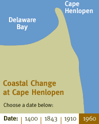
Coastal Change
While the Delaware Bay had achieved its present general outline by 800 BC, there were still many smaller changes to the coastline as the Bay evolved. The map at the left shows a 1960 view of Cape Henlopen, Delaware, which is located at the "end" of the Delaware Bay and the "beginning" of the Atlantic Ocean.
Scroll over the dates on the map to see the gradual development of Cape Henlopen, from 1400 to the present. Over that 600 year period, flood tides deposited sediment from the Atlantic beaches and the Cape continued to grow northwards. This slowed by 1900, when the advancing Cape Henlopen came abreast of an inner breakwater and effectively prevented the flood-tide currents from reshaping the coast.
Note that, in 1400, the hills surrounding Cape Henlopen were occupied by late Woodland Period Indians; the open lagoon may have provided an abundant supply of shellfish to those inhabiting this area.
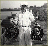
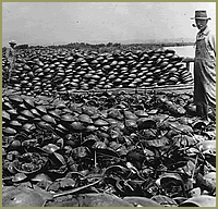
Photos from Delaware Public Archives, Board of Agriculture Collection
Top: William E. DeWitt holding "king crabs", June 28, 1928
Bottom: "King crabs" near Bowers
June 17, 1924
Horseshoe Crab Harvesting
The harvesting of horseshoe crabs for fertilizer, which began in the 1800s, continued and increased as the demand for fetilizer grew. Archival photographs from the early 1920s illustrate the large number of horseshoe crabs that were gathered during that time. During the late spring and early summer of 1856, some 1,200,000 animals were collected within one mile of the Cape May, New Jersey shoreline.
By the 1940s, commercial fertilizer that used chemical compounds had been developed and the demand for horseshoe crab harvesting rapidly declined. Harvesting of horseshoe crabs declined from a high of 5 million in 1870 to 1-2 million during the 1940s. Substantial commercial scale harvesting of horseshoe crabs ceased in the 1960s.
It was not until recently that the horseshoe again began to be harvested in large numbers, this time as bait for the eel and conch fisheries.